Maps of New South Wales
Sydney Australia Maps
North NSW Maps
- Central Coast Map, NSW Beaches, National Parks, Towns
- Hunter Valley Map NSW
- Map of the North Coast NSW
- Mid North Coast Map NSW - Attractions, Places of Interest
- Far North Coast Map NSW
Northern Rivers NSW
South NSW Maps
- Macarthur Region Map
- Southern Highlands Map NSW
- Illawarra and Wollongong Map, NSW
- South Coast Map NSW
- Far South Coast Map NSW
West NSW Maps
NSW Maps
- Maps of New South Wales
- South West NSW Map
- North West NSW Map
- North East NSW Map
- South East NSW Map
- Map of NSW Australia
- West NSW Map
- East Coast NSW Map
- NSW Regions Map, Australia Tourist Information
- NSW Map - Australia Tourist Guide
- NSW Touring Map
- Mimosa National Park
Australia Tourist Guide
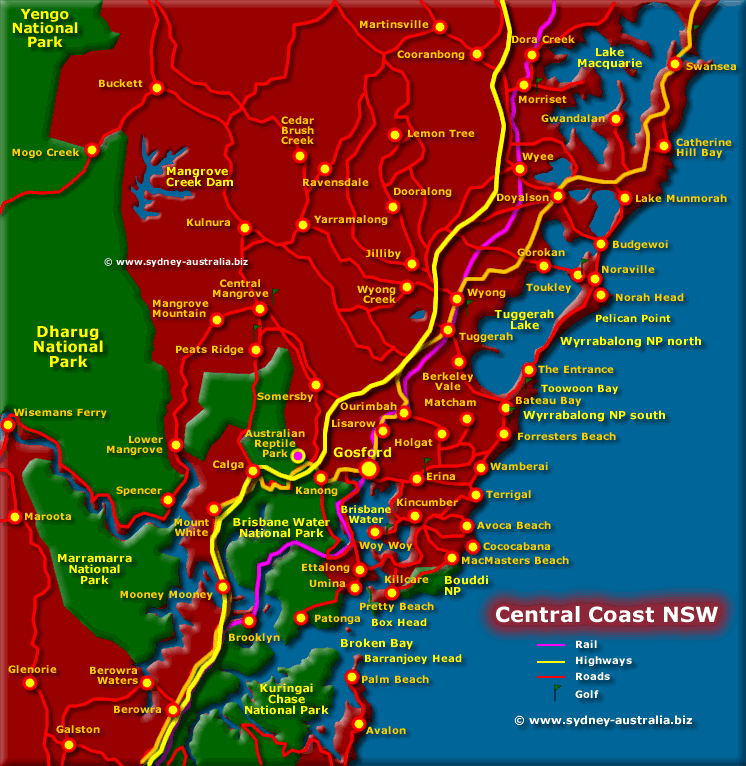
Central Coast Map, NSW Beaches, National Parks, Towns
Map of the South Coast of New South Wales showing location of Central Coast towns, places to visit, beaches and National Parks - including Woy Woy in the south, Ettalong, Gosford, Terrigal, The Entrance, Wollombi, Tuggerah with Toukley and Wyong in the North.
On the Central Coast you will find beautiful beaches, sparkling ocean, lakes and rivers with a backdrop of the Watagans mountains. Sydneysiders have long been travelling here as an escape to relax, while taking in the regional scenic splendour and adventures on offer.
Places to Visit on the Central Coast
All along the coast of NSW there are sleepy villages nestled amongst the headlands, long golden sand beaches, pristine forest national parks and a great lifestyle to match. This includes the Central, North as well as the South Coast region.
Coast of NSW
NSW Regions
Greater Sydney
Just to the south is the region of Greater Sydney, encompassing the suburbs and surrounds: Greater Sydney Surrounds Map.
NSW Attractions, Museums and Art Galleries
Museums in Sydney and the rest of NSW: Museums in New South Wales.
Art Galleries: NSW Art Galleries.
NSW Attractions: NSW Attractions.
NSW Hotels and other Accommodation
New South Wales accommodation includes hotels, motels, luxury resorts, caravan parks, camping, bed and breakfasts, backpackers and youth hostels.
Main Photo: Map of the Central Coast NSW
Search the Australia Tourist Guide |


