Maps of New South Wales
Sydney Australia Maps
North NSW Maps
- Central Coast Map, NSW Beaches, National Parks, Towns
- Hunter Valley Map NSW
- Map of the North Coast NSW
- Mid North Coast Map NSW - Attractions, Places of Interest
- Far North Coast Map NSW
Northern Rivers NSW
South NSW Maps
- Macarthur Region Map
- Southern Highlands Map NSW
- Illawarra and Wollongong Map, NSW
- South Coast Map NSW
- Far South Coast Map NSW
West NSW Maps
NSW Maps
- Maps of New South Wales
- South West NSW Map
- North West NSW Map
- North East NSW Map
- South East NSW Map
- Map of NSW Australia
- West NSW Map
- East Coast NSW Map
- NSW Regions Map, Australia Tourist Information
- NSW Map - Australia Tourist Guide
- NSW Touring Map
- Mimosa National Park
Australia Tourist Guide
Illawarra and Wollongong Map, NSW
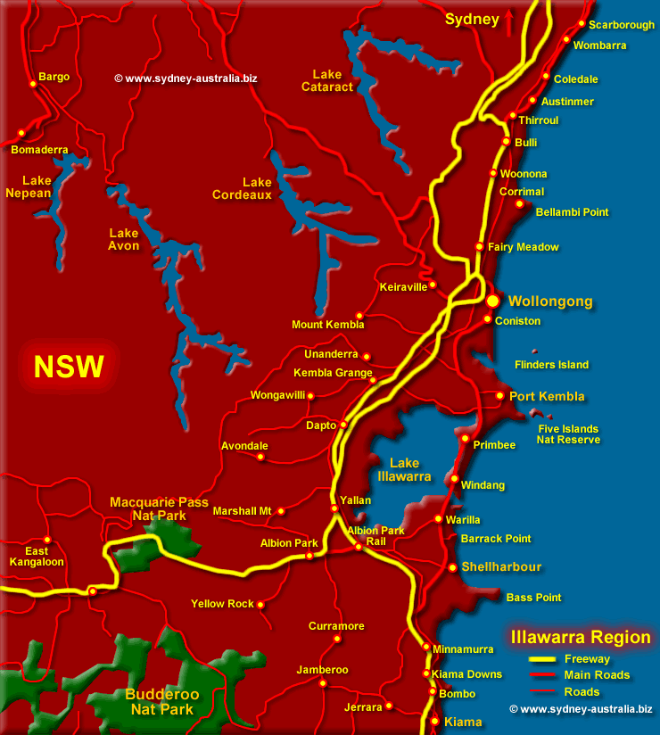
Map of Illawarra NSW - shows towns including the city of Wollongong, roads and National and State Parks. See more Illawarra and Wollongong NSW.
Showing location of Macquarie Pass National Park, Wollongong, Kiama, Shellharbour, Port Kembla, Jamberoo, Fairy Meadow and surrounding towns and area. Also lakes, state and national parks.
Wollongong is the third largest city in New South Wales and is both cosmopolitan and on the coast, with lots of beaches, things to do and places of interest to visit.
Next Picture: South East NSW Map - South East NSW Map.
Previous Picture: North West NSW Map - North West NSW Map.
Kangaroo Valley
Kangaroo Valley is just west from the South Coast and considered a good place to sight not only the variety of colourful birdlife, but other Australian wildlife within the hilly surrounding forests and bushland.
Go shopping for bargains at the many antique and art galleries, visit museums, craft markets and shops, as well as exploring the South Coast of New South Wales.
To Get to Illawarra NSW
Proceed south along the Princes Highway from Sydney - Approx 1.5 hours drive from Sydney.
Weather for Wollongong and Illawarra
Weather for Wollongong and Illawarra Weather for Wollongong and Illawarra.
Maps of NSW
Accommodation NSW
You can find places to stay all along the South Coast, some set in truly stunning locations. Beach cabins, holiday homes, serviced apartments in one of the small fishing villages or hotels in town. Search for Wollongong and Illawarra Accommodation.
Main Photo: Map of Illawarra - Click to see more about Illawarra NSW
Search the Australia Tourist Guide |


