Maps of New South Wales
Sydney Australia Maps
North NSW Maps
- Central Coast Map, NSW Beaches, National Parks, Towns
- Hunter Valley Map NSW
- Map of the North Coast NSW
- Mid North Coast Map NSW - Attractions, Places of Interest
- Far North Coast Map NSW
Northern Rivers NSW
South NSW Maps
- Macarthur Region Map
- Southern Highlands Map NSW
- Illawarra and Wollongong Map, NSW
- South Coast Map NSW
- Far South Coast Map NSW
West NSW Maps
NSW Maps
- Maps of New South Wales
- South West NSW Map
- North West NSW Map
- North East NSW Map
- South East NSW Map
- Map of NSW Australia
- West NSW Map
- East Coast NSW Map
- NSW Regions Map, Australia Tourist Information
- NSW Map - Australia Tourist Guide
- NSW Touring Map
- Mimosa National Park
Australia Tourist Guide
Map of the North Coast NSW
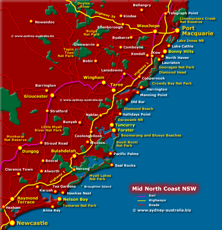
Map of the North Coast NSW - Beaches, Towns and National Reserves and Parks. See more about Port Macquarie, the Great Lakes North Coast of NSW.
The map shows Newcastle, Dungog, Bulahdelah, Gloucester, Wingham, Taree, Wauchope, Raymond Terrace, Nelson Bay, Tuncurry, Forster, Old Bar, Port Macquarie, Myall Lakes, Bonny Hills, Harrington and surrounding area. Also national parks, towns, and beaches on the NSW North Coast.
There is more than sun, surf and beach culture available - golf, markets, agricultural shows, race meetings and music festivals.
Then there are chances for bargains at the many antique and art galleries, museums, craft markets and shops, as well as exploring the fine wines and dining made from local produce.
Getting to the NSW North Coast
To get to the NSW North Coast - Take the Pacific Highway over the Sydney Harbour Bridge to Highway 1 at Hornsby, then head towards Newcastle and beyond up to the NSW North Coast.
North Coast Further Reading
- North Coast NSW
- Visit Bellingen and Surrounds
- Coffs Coast Activities
- Coffs Harbour NSW
- Coffs Coast Weather
- Evans Head and Surrounds
- Foster Tuncurry NSW
- Gondwana Rainforests of Australia
- Visit Iluka and Surrounds
- Kempsey, NSW
- The Great Lakes NSW
- Macleay Valley NSW
- Port Macquarie NSW
- Port Stephens and Surrounds
- South West Rocks and Surrounds
- Taree NSW Manning Valley
- Wauchope and Surrounds
NSW Maps
Australian Wine Growing Regions
To see some of the great Australian wine growing regions Australian Wine Growing Regions.
Main Photo: Map of the Mid NSW North Coast - Click to see More Information
Search the Australia Tourist Guide |


