Maps of New South Wales
Sydney Australia Maps
North NSW Maps
- Central Coast Map, NSW Beaches, National Parks, Towns
- Hunter Valley Map NSW
- Map of the North Coast NSW
- Mid North Coast Map NSW - Attractions, Places of Interest
- Far North Coast Map NSW
Northern Rivers NSW
South NSW Maps
- Macarthur Region Map
- Southern Highlands Map NSW
- Illawarra and Wollongong Map, NSW
- South Coast Map NSW
- Far South Coast Map NSW
West NSW Maps
NSW Maps
- Maps of New South Wales
- South West NSW Map
- North West NSW Map
- North East NSW Map
- South East NSW Map
- Map of NSW Australia
- West NSW Map
- East Coast NSW Map
- NSW Regions Map, Australia Tourist Information
- NSW Map - Australia Tourist Guide
- NSW Touring Map
- Mimosa National Park
Australia Tourist Guide
NSW Map - Australia Tourist Guide
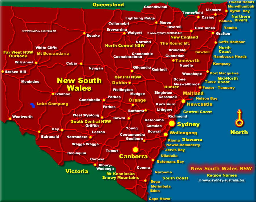
Tourist Map of New South Wales Australia - showing regions, cities and towns. See more about NSW Australia.
The map shows the Sydney region, Central Coast, South Coast, North Coast, the Northern Rivers, North Central and Central.
Visit Katoomba to see the Three Sisters and spectacular views as well as the very colourful birdlife. The Blue Mountains National Park has lots of places to explore as well as the Zig Zag Railway.
Then there are chances for bargains at the many antique and art galleries, museums, craft markets and shops, as well as exploring the fine wines and dining in the restaurants dotting the mountains.
Search for Sydney Accommodation
You can search by Name or Chain, or type of accommodation with the location. Popular places to stay include Sydney City and Airport, but for something different yet easily accessible to the city centre try The Rocks, Darling Harbour, Manly Beach, Cronulla Beach, Coogee Beach or Bondi Beach. The beach suburbs in Sydney are popular places to stay as they cater for everyone, including families.
Regional Maps of New South Wales
Getting to the NSW Blue Mountains
To get to the NSW Blue Mountains from Sydney - Approx 1.5 hours drive west.
Take the F4 west in the direction of Penrith, then head further west towards Katoomba.
You can travel all the way to the other side to Lithgow or return via the Bell Road, for spectacular views of Sydney.
New South Wales MapsMaps of the State of NSW with regions, cities, major towns, places to visit and national parks: |
|
New South Wales Accommodation
New South Wales accommodation includes hotels, motels, luxury resorts, caravan parks, camping, bed and breakfasts, backpackers and youth hostels.
Main Photo: Map of New South Wales - Click to see More Information
Search the Australia Tourist Guide |


